There are a number of ways to solve the map matching problem, the demonstration below uses one simple approach. Perhaps the best way to explain the algorithm is with the simple example shown below:
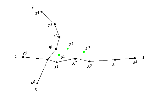
In this example, the person started at P0, the intersection of arcs A, B, C, and D (where A0 = B0 = C0 =D0). Then, three positions were recorded, P1, P2, and P3. We want to determine the distances between the piecewise-linear curve formed by connecting P0 ... P3 and A, B, C, and D, respectively.
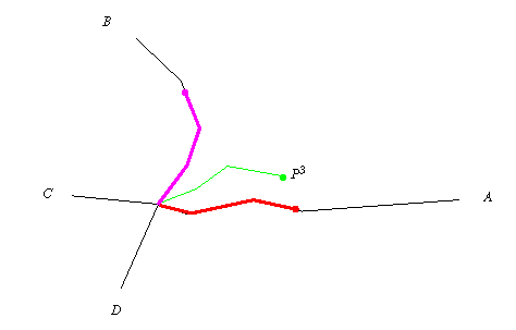
The initial steps in the process are illustrated in the following Figure. First, a piecewise-linear curve is constructed by connecting P0, P1, P2, and P3. Then piecewise-linear curves of equal length are constructed along all of the arcs emanating from this same intersection. (For simplicity, we limit our attention only to arcs A and B.)
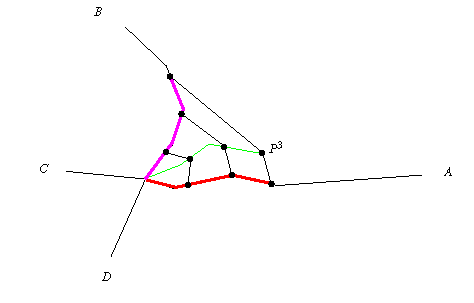
Next, as shown in the Figure below, each of the piecewise-linear curves is divided into s segments of equal length. (In this example, s=3.) Finally, the relevant distances are calculated. In this example, arc A is clearly the closest and P3 is matched to it.
This demonstration simulates a vehicle driving around on a street network. The vehicle is equipped with an AVL system that provides it with its approximate location. In this demonstration:
As you can see, even the "matched" locations are not perfect. This is because the algorithm being used in this demonstration has been kept extraordinarily simple. Even so, the "matched" locations are generally much better than the raw locations provided by the AVL.